The Rising Snowline: Montane wet meadows and their changing snowpack as complex environmental systems
Studies on climate change and snowpack dynamics in the Sierra Nevada mountains of California have focused on fundamental questions related to water supply: How will the timing of snowmelt change? How much precipitation will fall as snow? How will the baseline April 1st snow water equivalents change? As environmental conservation and restoration strategies begin to address adaptation to climate change, we require more knowledge about ecosystem interactions with the forced rise of atmospheric carbon and observed increases in temperatures and extremes in precipitation. Increasingly, conservation agencies have posited the restoration of wet meadows as a climate change mitigation measure.
The National Fish and Wildlife Federation’s Sierra Nevada Meadow Restoration Business Plan (2010) posits that “meadow restoration in the Sierra Nevada could increase the amount of groundwater storage in and released from meadows by 50,000 to 500,000 acre-feet annually” with a myriad of other ecosystem service benefits. The investment component of the plan consists of a $210 million to repair 60,000 acres of degraded meadows, validate ecosystem service benefits, build organizational capacity, and support conservation-based land management. The plan acknowledges uncertainties in the magnitude of groundwater storage, response of individual threatened species to restoration, and quantification of ecosystem service benefits. It also recognizes the complexity introduced by geologic and hydrologic heterogeneity across the elevations and latitudes of the Sierra Nevada. In addressing risks to success, the plan calls out the need for linked groundwater-surface flow models and surface water hydraulic models to “develop more accurate estimates of watershed processes that meadows provide.” While these models may predict quantities of groundwater and surface flows in individual meadows over restricted timescales and given certain boundary conditions, we may also gain an understanding of the complexities of the interactive couplings between climatic, geomorphic, ecologic, and hydrologic processes and variables through models that simplify hydraulic representations while incorporating interactions between temperature, vegetation, snowpack, soils, sediment and geology.
Wet meadow ecosystems of the Sierra Nevada of California, with their concomitant land uses and management regimes (grazing, timber extraction, roads, fire suppression, and exurban development) have not only witnessed degradation, but an apparent shift to an alternate, resilient state of a dry meadow ecosystem characterized by water table elevation and vegetation community. Wet meadow degradation is generally seen more as an alternative stable state or catastrophic shift rather than a successional model, as Suding (2004) describes. Although fingers point to several initiating mechanisms of degradation over a 150-year history of over-grazing, meadow drainage, channel straightening, and both timber extraction and then fire suppression (Merrill 2012 for a review), channel incision is a common outcome of these shift initiators, which lead to groundwater drainage and less frequent bank overflows (Figure 1). Subsequent shifts to more sparse, xeric vegetation due to drained water tables and continued grazing may actually increase sediment yields and weaken bank stability but in reports by the U.S. Forest Service and community restoration groups, the incision state appears recalcitrant without the active forcing of a restoration project.
A common restoration technique in the Sierra, known as ‘pond and plug,’ has been used where channels have been straightened and then incised. With heavy machinery, the straightened channel is plugged at key intersections with the historic channel using excavated soils and aggregate, redirecting flows into historic meanders, elongating channel length, reducing channel depth and slope, and thereby increasing frequency of overbank flows, elevating groundwater levels and restoring herbaceous wet meadow vegetation communities. As a secondary restoration outcome, deep ponds (and often grade control structures) are introduced as novel features of the ecosystem. In many cases managed grazing continues, forest management practices remain unchanged and channel management measures, such as beaver pond drainage, attempt to ensure a degree of channel stability. Evidence suggests that the ‘pond and plug’ technique, now employed for nearly 20 years, has increased groundwater elevations and restored vegetation communities in several meadows concentrated in the northern Sierra (Merrill 2012, Hammersmark et al 2008).
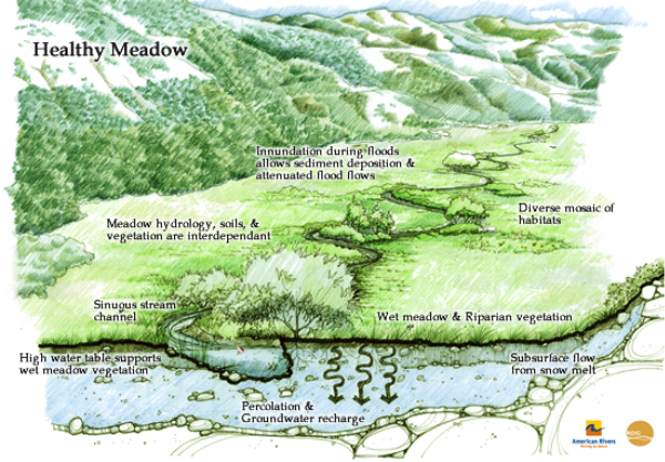
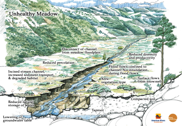
Figure 1. Representations of wet and dry meadows as healthy and unhealthy alternative stable states.
As Suding (2004) discusses, “models of alternative states incorporate feedbacks and alternative internally reinforced states.” The specific feedbacks and thresholds that initiated degradation (i.e. land, forest and fire management) may not be addressed by channel-focused projects. Grazing management plans, however, can and sometimes do include “percent vegetative cover” thresholds as indicators of over-grazing, triggering management actions. The effects of climate change and the introduction of novel features remain areas to incorporate into conceptual models of meadow ecosystems, but in general current conceptual models focus on incision as the “problem” rather than a set of integrated, non-linear, cross-scale processes within a complex environmental system. A potential “first cut” of the feedbacks and interactions within a conceptual model for wet meadow ecosystems follows in Figure 2.
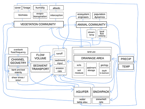
Figure 2. Draft conceptual model of eco-hydro-geomorphic interactions in wet meadow ecosystems
During the semester, we’ve discussed and studied a range of modeling paradigms that attempt to represent the non-linearities and emergent properties of complex socio-ecologic systems. These non-linearities and emergent properties can lead to self-organized pattern formations or reveal sensitivities to threshold-based catastrophic shifts in populations or transitions to alternative stable states. In addition to our readings, Werner (2003) presents a framework for categorizing models of geomorphic landforms. As echoed in discussions in class and the RCM workshop, he posits that modeled predictions tests hypotheses and models with fewer variables and interactions rely less on assumptions at initial, boundary and forcing conditions and therefore can be tested more rigorously. In his continuum of model types, he discusses two end-member extremes: reductionist versus universal models. Reductionist models represent variables and dynamics at the fundamental scale of the continuum conservation laws whereas the universal models simplify dynamics into rules representing behaviors in a simplified interactions with as few variables as possible. Because universal models represent less detail and have sensitivity to initial conditions, they can run for longer time scales than reductionist models which are subject to amplified numerical and conceptual errors unless constrained to smaller, faster time scales. Between these two end-members, Werner fills the gulf with hybrid, abstracted models which are organized into temporal hierarchies allowing for self-organization and emergent patterns to play out over long time scales. A potential framework for spatial and temporal hierarchies of wet meadow ecosystems follows in Tables 1 and 2.
Table 1. Critical Time Scales of Wet Meadow Ecosystems
|
Time Scale |
Process |
|
Daily |
temp flux, evaporation, plant transpiration, vadose zone interactions, diurnal stream flows, atmospheric turbulence and local wind patterns, |
|
Seasonal |
temp flux, daylength, snowpack dynamics, melt-driven peak runoff, summer drought and baseflows, soil moisture flux, plant biomass and phenology, animal phenology |
|
Annual |
climate cycles, water supply balances, biotic population flux, prescribed burns |
|
Multi-Decadal |
ENSO precipitation patterns, channel forming storm events, atmospheric carbon increases, wildfire, forest dynamics, land use practices |
|
Mutli-Centennial |
climate and vegetation shifts, wildfire, extreme storm events, sediment yields, soil formation |
|
Geologic |
erosion rates, tectonic movement |
Table 2. Critical Spatial Scales of Wet Meadow Ecosystems
|
Spatial Scale |
Patterns and Process |
|
Micro (<mm) |
soil micro-organisms, plant photosynthesis |
|
Granular (sub-m) |
macro-invertebrates, fish and amphibian reproduction, sediment movement, vegetation/soil capillary processes, vertical and hyporheic water flows |
|
Meander/Patch (m) |
in-channel secondary flow patterns, bar formation, veg species, animal forage, cover and movement (invertebrates, fish, amphibian, bird, mammal) |
|
Meadow (multi-m) |
soil and snowmelt patterns, meadow veg communities, animal (fish, amphibian, bird, mammal) movement, humidity and soil moisture patterns |
|
Drainage Area (km) |
orographic effects, wind patterns, snowpack dynamics, geologic formations, forest matrix, animal population dynamics (fish, bird, mammal) |
|
Region/State (multi-km) |
precipitation patterns and weather fronts, water supply and demand, forest service investments and strategies, grazing demand and rancher livelihood |
|
Global |
carbon forcing, climate, natural resource economics |